Winnipeg might be denser than you think, and that’s a good thing.
Earlier this week, I got in a bit of a tiff on r/winnipeg1 about Winnipeg’s embarrassing lack of trains. In which, the OP insisted that Winnipeg did not have the population density to support an LRT.
This led me down a rabbit hole, with one fundamental question.
What is Winnipeg’s population density?
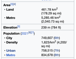
If you look at Wikipedia, you’ll see Winnipeg’s current population density listed as 1,623/km2.
This is technically, mathematically correct. If you divide Winnipeg’s current population of 749,607 by the land area of Winnipeg’s city limits 461.78km2 you’ll end up with that value.
However, Winnipeg’s city limits contain a heck of a lot of farm and undeveloped land, where the population density is essentially 0. As you can clearly seen on Google Maps.
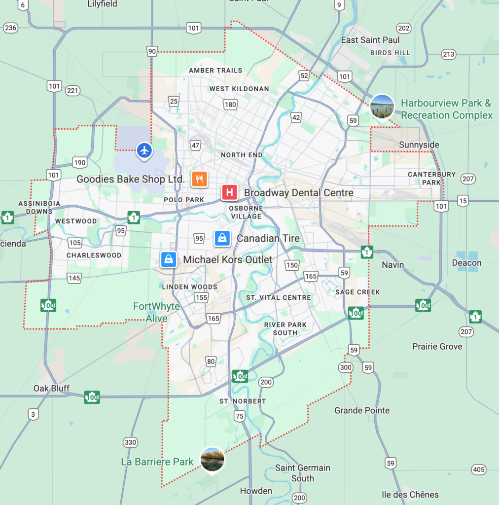
Contrary to popular belief, it does not align with the Perimeter Highway.
Population Centres
In this rabbit hole, I learned about Statistics Canada’s “population centre” designation:
A populated place, or a cluster of interrelated populated places, which meets the demographic characteristics of an urban area, having a population of at least 1,000 people and a population density of no fewer than 400 people per square km2.
It captures where people actually live in an urban pattern, ignoring things like farmland and parks.
If you’re planning something like a transit system, it’s not really relevant that the city boundaries include a bunch of unoccupied land.
By removing the unoccupied land and including other adjacent occupied land, the population centre map allow us to calculate the population density where people actually live, i.e the area that the city actually needs to service.
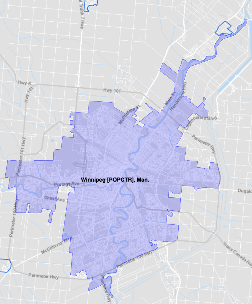
Note that not only does it exclude all the farmland on the outskirts, it also excludes Assiniboine Forest and Park.
Winnipeg’s True Population Density
Our population centre density is 2,124.8/km2.
That puts us 10th in the country. Somewhat surprisingly, just barely behind Regina. And just above Oshawa.
Cities with LRT
How does Winnipeg’s population centre density compare to other cities with trains?
| Toronto | 3,087.8 |
| Montreal | 2,658.4 |
| Vancouver | 2,661.3 |
| Calgary | 2,099.9 |
| Ottawa-Gatineau | 1,965.7 |
| Edmonton | 1,836.2 |
| Waterloo2 | 611.1 |
Do some of those cities have other population centres directly attached to them? Sure. But those places also have multiple transit options.
Neighbourhood Density
At one point in the conversation, OP cited a number of 70 – 140 people per hectare3. Which seemed incredibly high, especially since Toronto’s average population density is only 30.9/ha.
The number comes from a 2011 Pembina Institute report on merits of LRT vs a new subway line in Toronto (PDF). Upon further reading, context of that number seems to be the “neighbourhoods they serve.” It’s not well defined, but I assume this means something like walking distance from the station.
So then I wondered if it would be possible to find the density of neighbourhoods within Winnipeg.
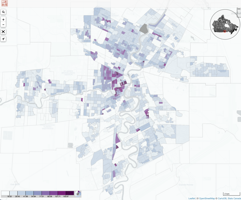
Here’s the 2021 census data plotted on a map.
Observations
I was surprised to see just how dense Winnipeg’s downtown is. Especially East Broadway. While obviously there are a tonne of apartment blocks around there, it feels dead4. There’s not a lot going on in this part of the city.
One or two mid-rise apartment buildings can easily push an individual city block’s density above 300 or 400 per ha. Which leads to some unexpected micro pockets of density.
The North End seems generally denser that I would have expected.
If you look at the key, it’s easy to see that are definitely several obvious neighbourhoods around the 70/ha+ threshold needed to support LRT (according to the Pembina Institute in 2011).
So what?
I dunno… I just found these numbers interesting. Particularly the concept of “population centres.”
I have no idea if these numbers alone are enough to justify investing in rail.
But it does feel validating to find out that other cities with LRT are much less dense than Winnipeg. At the very least, I think these numbers explain why it feels so embarrassing to me.
Oh, and absolutely do not take this post to mean that I am denying Winnipeg’s serious sprawl problem. Scroll back up to that map and look at the vast swaths of light blue.
- I considered linking to the thread but thought best not to. DM me if you’re really interested. ↩︎
- This one is a bit of an outlier because of the whole tri-cities thing: https://en.wikipedia.org/wiki/Regional_Municipality_of_Waterloo ↩︎
- 100ha = 1km2 ↩︎
- Maybe this is a new observation about the character of Winnipeg: It’s plenty dense, but it’s not lively. Winnipeg’s built like a city, but doesn’t act like one. There’s nothing going around Broadway, nobody is out and about. ↩︎
Leave a Reply
Only people in my network can comment.